About the Ecola Point Rocky Shore Area
Description
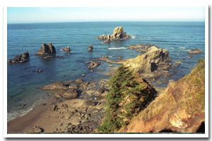
Approximately 1.5 miles of cliff, rocky intertidal, and nearshore rocks south of Tillamook Head at Ecola Point. The site is immediately adjacent to Ecola State Park, and within the park can be accessed via the Ecola Point parking area (the first of two parking areas off the main park road). Ecola State Park can be found west of US 101 (on Ecola Park Rd.), 2 miles north of downtown Cannon Beach, Oregon. |
|
Designation
Sea Lion Rock (offshore of Ecola Point) is part of the USFWS Oregon Islands National Wildlife Refuge. Access to all offshore rocks is prohibited, as they are important habitat for birds and marine mammals. Intertidal areas are not yet designated. |
| |
|
|
Key Resources
Intertidal areas have typical assemblages of marine invertebrates. Sea Lion Rock, associated unnamed small rocks, and cliff face are breeding habitat for five species of seabirds including bald eagles, brown pelicans and common murres. Steller sea lions and harbor seals use rocks in the area as haulouts. |
|
What can you do here?
The majority of visitors use the upland park area for picnicking and sightseeing. Some visitors explore tidepool areas and beachcomb. The beaches in the area are popular surfing spots. |
Educational Opportunities
Oregon Parks and Recreation Department has a seasonal (summer) rocky shores interpreter stationed at Ecola State Park. The interpretive ranger gives talks and is available to answer questions at Indian Beach, Hug Point and Cape Falcon (Oswald West State Park). Schedules vary by tidal cycle and time of year. Contact Ecola State Park (503-436-2844) for questions about the interpretive program schedule. There are two nice viewpoints with interpretive signs and benches. Interpretive signage focuses on the site’s offshore rocks role as a habitat refuge for birds although there is also a “Welcome to Our Home” rocky intertidal sign.
Getting to the Rocky shore at Ecola Point
Some of the rocky shore is accessible from Crescent Beach (which is accessed easily by way of an improved trail from the Crescent Beach parking lot). Another way to get down to the rocky shore is via a trail, which starts out on the south side of the parking area and is approximately 1 mile long (one-way).
 Public Access Option 1 for Ecola Point Rocky Shore Public Access Option 1 for Ecola Point Rocky Shore
Public Access Option 2 for Ecola Point Rocky Shore
Who Owns this Site?
Submerged and submersible lands (intertidal area): Division of State Lands; rocks above Mean High Water: U.S. Fish and Wildlife Service; upland is all owned by Oregon Parks and Recreation Department (OPRD). |
|
Who Manages this Site?
  Oregon Parks and Recreation Department (OPRD) manages public access and recreation on the ocean shore. This site is within OPRD Area 1 and part of the Nehalem Bay Management Unit. Oregon Parks and Recreation Department (OPRD) manages public access and recreation on the ocean shore. This site is within OPRD Area 1 and part of the Nehalem Bay Management Unit. |
|
Data for the Ecola Point Rocky Shore
[1 Records Listed]
Ecola Point Rocky Shore GIS Data |
Data Layer |
Source |
Scale |
Year |
Download |
|
ODOT |
6,000 |
1967 |
|
[1 Records Listed]
Information compiled by Laurel Hillmann, NOAA Coastal Management Fellow, OPRD |