About the Otter Crest / Devil's Punchbowl Rocky Shore Area
Description
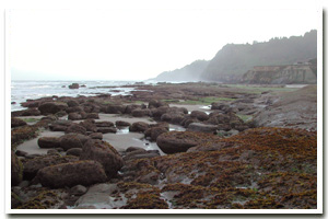
One mile of intertidal habitat approximately five miles south of Depoe Bay in the town of Otter Rock, Lincoln County, Oregon |
|
Designation
 Marine Garden. The Otter Rock marine garden encompasses “all rocky areas, tide pools, and sand beaches situated between extreme high tide and extreme low tide lying between a line projected due west from the highest point of Cape Foulweather visible from the shore (Otter Crest State Wayside) on the north, to a line projected due west from the Devil’s Punchbowl on the south.” Marine Garden. The Otter Rock marine garden encompasses “all rocky areas, tide pools, and sand beaches situated between extreme high tide and extreme low tide lying between a line projected due west from the highest point of Cape Foulweather visible from the shore (Otter Crest State Wayside) on the north, to a line projected due west from the Devil’s Punchbowl on the south.” |
| |
|
|
Key Resources
High public-use intertidal habitat; 3 small seabird colonies; harbor seal haulout; opportunities for natural resource interpretation. |
|
What can you do here?
Devil’s Punchbowl State Natural Area/Otter Crest is a very popular and heavily used area for recreational activities such as tidepooling, sightseeing, sport fishing from shore, photography, marine mammal viewing, dog walking and adjacent beach use. School groups also often use the area as an educational resource. The status of the area as a marine garden means that all collection of intertidal shellfish and marine invertebrates is prohibited except single mussels for bait. |
Educational Opportunities
On site interpretation includes a “Welcome to Our Home” rocky shore intertidal habitat sign near the pathway down to the marine garden and several other interpretive panels (including one that discusses the geology of the punchbowl itself and one about “Oregon’s Rocky Shores”) at the overlook at Devil’s Punchbowl.
Getting to the Rocky shore at Otter Crest / Devil's Punchbowl
Public access is via a relatively easy gravel trail down from the parking area at Devil’s Punchbowl State Natural Area. The stairwell owned by Oregon Parks and Recreation Department is taken down seasonally due to high wave action in the area. Private access is available from the Inn at Otter Crest.
 Public Access Option 1 for Otter Crest / Devil's Punchbowl Rocky Shore Public Access Option 1 for Otter Crest / Devil's Punchbowl Rocky Shore
Public Access Option 2 for Otter Crest / Devil's Punchbowl Rocky Shore
Who Owns this Site?
Submerged and intertidal lands: Division of State Lands; beaches: Oregon Parks and Recreation Department which also owns the adjacent section of park. All other adjacent upland is in private ownership. |
|
Who Manages this Site?
  Currently managed as a Marine Garden by Oregon Department of Fish and Wildlife (ODFW). Some of the adjacent upland area is managed by Oregon Parks and Recreation Department (OPRD) as Devil’s Punchbowl State Natural Area, which is part of OPRD Area 3 and the Beverly Beach Management Unit. OPRD manages Oregon’s beaches and rocky shores as part of the ocean shore recreation area. Currently managed as a Marine Garden by Oregon Department of Fish and Wildlife (ODFW). Some of the adjacent upland area is managed by Oregon Parks and Recreation Department (OPRD) as Devil’s Punchbowl State Natural Area, which is part of OPRD Area 3 and the Beverly Beach Management Unit. OPRD manages Oregon’s beaches and rocky shores as part of the ocean shore recreation area. |
|
Data for the Otter Crest / Devil's Punchbowl Rocky Shore
[3 Records Listed]
Otter Crest / Devil's Punchbowl Rocky Shore GIS Data |
Data Layer |
Source |
Scale |
Year |
Download |
|
ODFW |
100,000 |
2008 |
|
|
ODOT |
6,000 |
1967 |
|
|
ODFW |
24,000 |
2010 |
|
[3 Records Listed]
Information compiled by Laurel Hillmann, NOAA Coastal Management Fellow, OPRD |